 RF
marcus@ctOS-2.0:~$ ./rf_sentinel --passive
RF Sentinel - police detector for Android
RF Sentinel is a free, open-source police detector for Android. It listens to the Bluetooth LE advertisements and WiFi beacons around you and flags police and surveillance equipment: body cameras, Flock and other plate-reader cameras, patrol-vehicle gear, trackers following you, Remote ID drones and camera glasses. It also watches the cell network for fake-tower (IMSI catcher) signs.
RX ONLYNo root · no Termux · no account · no analytics · GPL-3.0 · Android 8.0+ (ARM, 64 and 32-bit)
Signed APK from GitHub Releases. Not on Google Play. Install guide · Q&A
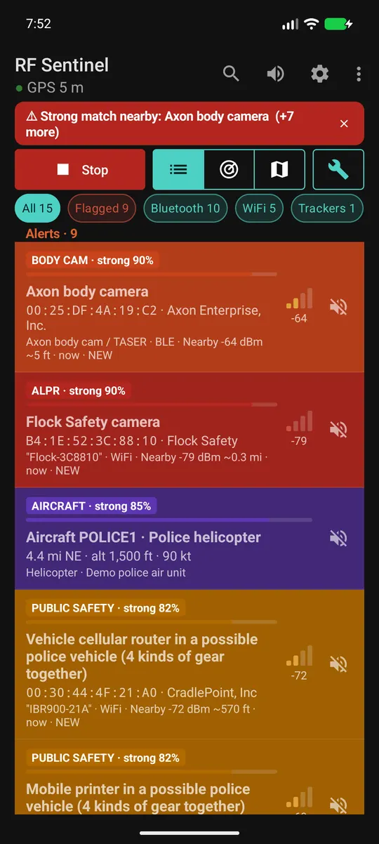
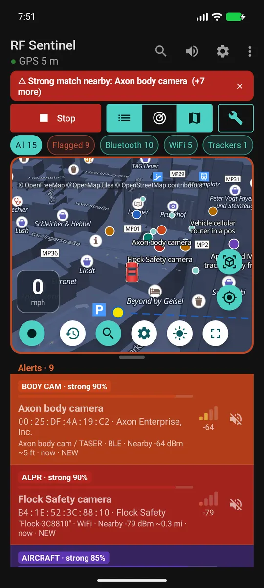
Police equipment it detects
| Category | Examples | How |
|---|---|---|
| Body cameras | Axon (TASER), Motorola / WatchGuard, Digital Ally, Zepcam, Vievu, Utility, Getac, in-car video | BWCDEVICE payload tag, company ID 0x034D, service UUIDs 0xFC81 / 0xFE6B / 0xFE6C, IEEE vendor prefixes |
| License-plate readers (ALPR) | Flock Safety, Genetec, Perceptics, Quercus, Tattile | Flock- SSIDs, Penguin- / FS- / FS Ext Battery BLE names, company ID 0x09C8, plus OpenStreetMap / DeFlock camera locations |
| Speed & red-light cameras | Fixed cameras mapped in OpenStreetMap | Offline map layer, warned about ~30 s ahead with the mapped limit |
| Audio sensors | Flock Raven gunshot detectors | 128-bit service UUIDs with short IDs 0x3100-0x3500 |
| Patrol vehicles | Two or more kinds of police-type gear moving together | RSSI correlation (Pearson r ≥ 0.6 over ≥ 8 s) across body cam, radio, in-car router, printer, rugged laptop roles |
| Public-safety gear | P25 / TETRA radio makers, in-car cellular routers (Sierra Wireless, Cradlepoint, Peplink, Inseego), in-car printers (Zebra, Brother), police radar makers, vehicle upfit, breath / drug screening devices | Company IDs, UUIDs, IEEE prefixes, Zebra factory-serial names |
| Trackers | AirTag & Find My, Google Find Hub, Samsung SmartTag, Tile, Chipolo | Separated-from-owner frames, then follow detection (default 10 min and 800 m with you) |
| Drones | Any ASTM F3411 / FAA Remote ID broadcaster (DJI, Skydio, Autel, Parrot...) | Decoded Remote ID over BLE and WiFi: serial, position, altitude, speed, heading, operator location |
| Camera glasses | Ray-Ban / Oakley Meta, Snap Spectacles, Vuzix, HeyCyan-based glasses such as Nilox Smart AI Glasses | Luxottica 0x0D53, Snap 0x03C2, Vuzix 0x060C, Meta UUIDs |
| Fake cell towers | IMSI catchers / cell-site simulators | Test MCCs, sudden 4G→2G, cloned or reserved cell IDs, unexpected networks (no root) |
| Card skimmers | Bluetooth modules inside gas-pump and ATM skimmers | HC-05 / HC-06 / HC-03 / RN42 / BT04-A names, serial-port service |
| Hacking tools (optional) | Flipper Zero, Pwnagotchi, WiFi Pineapple, deauthers, evil twin WiFi, Bluetooth spam floods, WiFi deauth attacks | Flipper IDs, Pwnagotchi beacon JSON, default network names, same network name from two makers with mismatched security, bursts of pairing pop-ups; with a USB WiFi adapter, floods of deauthentication frames knocking devices off a network |
| Emergency vehicles (V2X, Europe) | Police, fire, ambulance and safety cars broadcasting European car-to-car radio (ITS-G5) | An ESP32-C5 with the V2X2MAP firmware: the vehicle's role, light bar and siren state and its own position, and "emergency vehicle approaching" warnings. Not in North America (C-V2X) |
| Action & hidden cameras (optional) | GoPro, Insta360, DJI Osmo, YI, SJCAM, AKASO and other action cams; WiFi spy cameras in setup mode (V380, LookCam Pro...) | Bluetooth company IDs and services, maker prefixes, default camera and setup-hotspot network names |
| Two-way radios (RTL-SDR or HackRF) | Police, fire and EMS radios transmitting nearby: the North American public-safety bands, and TETRA handsets on 380-385 MHz (Europe and beyond) | Energy per 12.5 kHz channel on channels that are normally quiet, and TETRA's ~14 ms time-slot bursts; nothing is decoded |
| Police aircraft (optional) | Police, sheriff, state patrol, federal and RCMP / provincial police aircraft; unlisted aircraft circling low overhead | Community ADS-B feeds (adsb.fi / adsb.lol), and / or ADS-B heard directly by an RTL-SDR with no internet, matched against ~1,400 law-enforcement airframes from the FAA and Transport Canada registries |
| Waze reports (online, optional) | Police reported by Waze users, and any other kind you tick (accidents, hazards, road closures, traffic jams), inside an alert range you choose | Your own OpenWeb Ninja API key, or Waze direct (opt-in: sends Waze your IP address and a position rounded to a 1 km grid); scored by distance and age and re-scored every second as you move; third-party service, at your own risk |
Every match shows its evidence, its source and a confidence tier: weak (< 50), probable (50-79) or strong (80+). Full rules: how detection works and the signature reference.
What happens to every packet
Illustrative trace: actual scores depend on what each device advertises. The app logs the evidence the same way on each device's detail screen.
Features
Live list, radar & map
Every device in range (each leaves 30 s after it was last heard on Bluetooth, 60 s on WiFi, adjustable) with vendor, type, radio, RSSI, rough distance and NEW / ★ / FOLLOWING badges. Flagged devices sort first. Filter chips with live counts, by kind too (vehicles, phones, computers, audio, cameras, routers, hotspots, TVs, smart home, Apple, other), and the list grouped by category. Show the list, the radar and the map one at a time or together, resizable.
Alerts
Sound, vibration pattern per tier (1 / 2 / 3 pulses), spoken announcements through the phone's TTS, optional radar-detector beeps that speed up as a flagged device gets closer, discreet mode, floating threat bubble over Waze or Google Maps with a pop-up saying what was detected. Radar-detector sound style with selectable alert effects and an optional intro.
Navigation
Turn-by-turn directions on the map: search a place (Home, Work, starred and recent places are kept on the phone, and starred ones can be renamed; or long-press the map), pick one of up to three routes, avoid tolls, highways or ferries, and go. A banner shows the next turn, lane arrows and the turn after it; spoken directions play as navigation audio so your music dips under them; it re-routes by itself, takes stops, and finds petrol, charging or food along your route. Your arrival time follows how you really drive. Open the destination in Google Maps or Waze if you prefer. No live traffic. The map goes to its night look after sunset.
Map & traces
A vector map (OpenFreeMap, OpenStreetMap data, or Mapbox if you prefer) with your GPS trace, devices placed where their signal peaked and flagged ones pinpointed from every spot you passed (with the circle they're very likely in), history heatmap and timeline, offline known-camera layer. Save a snapshot of the device list to look at again later. North up, heading up, or a 3D driving view like a navigation app that zooms with your speed, with the default zoom and angle in Settings; a light map and a readable night map with shops, landmarks and one-way arrows. Optional CCTV layer: street, shop and building cameras mapped in OpenStreetMap, with their view cones.
Android Auto
Police alerts on the car screen as messages read aloud (reply "mute"), and an RF Sentinel screen with threats, cameras ahead, recent alerts and Scan / Mute buttons. The full car app with live map and navigation runs on Google's Desktop Head Unit. Details
Auto start in the car
Starts when the phone connects to your car's Bluetooth or Android Auto, stops when you leave. It can also record a trace of every drive by itself.
Sentinel Link
Link RF Sentinel phones near each other over Bluetooth with a 6-digit code: each one shows what the others detect, external hardware included, on its list, radar and map, marked VIA with the phone's name, with full alerts. Encrypted, no internet. Phones far apart can share through Meshtastic LoRa nodes, watchlist matches first (not yet tested on real hardware). Details
Tools
Cell towers (serving and neighbour cells, IDs, channel, signal, history, optional map layer and change alert) and WiFi channel / spectrum analyzers for 2.4, 5 and 6 GHz.
USB WiFi adapters
ALFA AWUS036ACS, AWUS1900, AWUS036ACM, AWUS036H, AWUS036NH / NEH, AWUS036NHA, AWUS036AXML / AXM, TP-Link Archer T3U and other RTL8812BU dongles - 2.4 GHz, 5 GHz on the AC adapters and 6 GHz on the WiFi 6E AWUS036AXML - in receive-only monitor mode over OTG, no root: no scan limit, longer range, devices connected to networks, and the network names devices ask for. The Bluetooth part of a combo adapter, or a USB Bluetooth dongle, adds a second Bluetooth LE scanner. Details
RTL-SDR and HackRF
An RTL-SDR dongle or a HackRF One on OTG notices two-way radios transmitting nearby, TETRA handsets by their time-slot bursts, and optionally cellular modems, from signal strength. It can also follow a P25 control channel (experimental: which talkgroups get a channel), play clear voice (analog FM, P25, DMR and NXDN; experimental, off by default; encrypted calls are never decoded), spot a vehicle following you by its tire-pressure sensors, receive ADS-B aircraft directly, with no internet, and shows a live radio waterfall of the watched bands (tap a signal to zoom in). The HackRF is used to receive only.
ESP32 boards
OUI-Spy over USB OTG or Bluetooth, GhostESP and Marauder over USB (dual-band on ESP32-C5, or through a Flipper Zero with a BFFB). The board's detections merge into the app. Details
Device details
Evidence, identity, decoded protocol data, signal graph, Locate mode (beeps faster as you get closer, keeps following a tag when it changes its address, and keeps going on the map, where a live read card shows the signal, rough distance and trend), history and the raw advertisement. Give a device your own name or write a note on it: the name shows in the list and on the map, and named or noted devices stay in the history. I saw it adds a device to your watchlist with what you say it is, including its Bluetooth advert pattern or WiFi probe fingerprint, so it's recognised next time even under a new random address. Search every device the app remembers, in range or not, by address, name, vendor, type, your name for it or your note.
Export
CSV, JSON, KML, GPX, GeoJSON. Match history and the watchlist are searchable. Everything stays on the phone until you export or share it.
13 themes and a theme maker
Including DedSec (Watch Dogs 2) and fsociety (Mr. Robot) fan themes with animated terminal headers, Night Drive red HUD, Night Vision, Amber CRT. Make your own: colours, font, banner, header and map marker, and share it as a file.
Screenshots
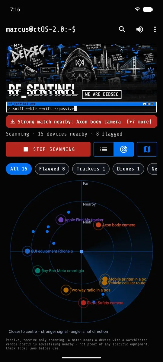
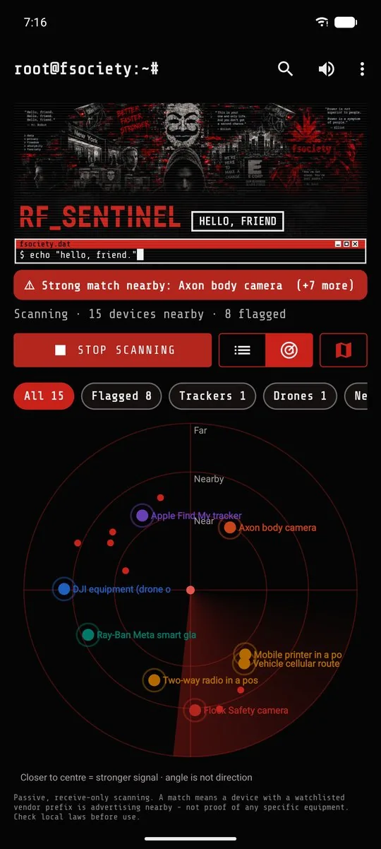
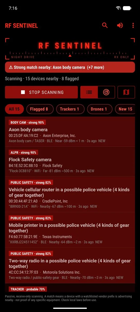
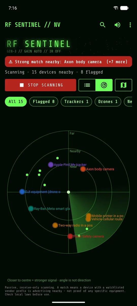
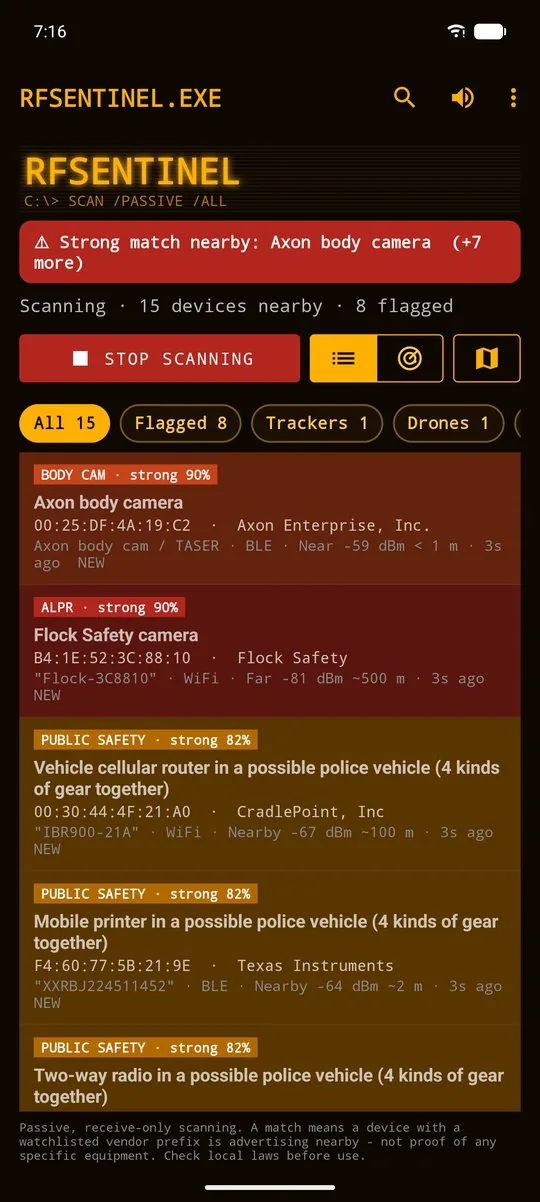
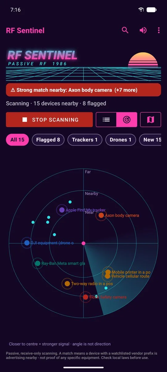
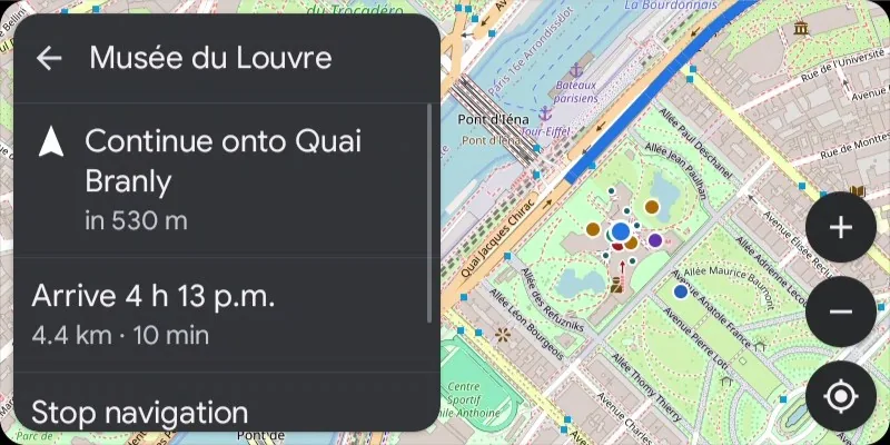
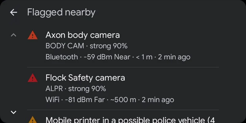
Screenshots use made-up demo devices run through the real detection pipeline.
Compared with other options
| RF Sentinel | Crowd-reported apps (Waze) | Phone's built-in tracker alerts | |
|---|---|---|---|
| Price | Free | Free | Free |
| Open source | GPL-3.0 | No | No |
| Works where nobody reported | Yes, reads the equipment's own signals | No, needs other drivers | Trackers only |
| Account / tracking | None | Location shared with the service | Phone account |
| Install | Regular APK | App store | Built in |
| Bluetooth LE / WiFi signatures | Yes | No | Trackers only |
| Police / ALPR / body cam rules | Yes, sourced | User reports | No |
| Remote ID drone decode | Yes | No | No |
| Fake cell tower signs | Yes | No | Android 15+ only (network notifications) |
| Android Auto | Yes, alerts and a status screen | Yes | No |
Crowd-reported apps and RF Sentinel work well together: one knows what other drivers saw, the other hears the equipment itself.
Guides
Detect police with Android
Body cams, radios, patrol-vehicle kits, e-ticket printers.
Flock & ALPR cameras
Radio signatures plus the OpenStreetMap / DeFlock camera map.
Stingray / IMSI catcher
What a non-rooted phone can and can't see.
AirTag & tracker detection
Find My, Find Hub, SmartTag, Tile and Chipolo on Android.
Remote ID drone detector
Drone and operator position from the broadcast.
Smart glasses detector
Ray-Ban Meta, Spectacles, Vuzix nearby.
Speed camera alerts
Offline speed, red-light and plate-reader warnings, and routes around them.
Police aircraft tracker
Police helicopters and planes overhead from ADS-B.
Hidden camera detector
WiFi spy cams, action cams, and Watch this place for a hotel room.
Card skimmer detector
Bluetooth skimmers in gas pumps and ATMs.
Flipper Zero & WiFi attacks
Flipper, Pwnagotchi, Pineapple, evil twins, deauth floods.
GPS jammer detector
Jamming and spoofing signs from the phone's own satellite receiver.
RTL-SDR on Android
Radio sweep, waterfall, ADS-B without internet, tire sensors.
P25 scanner
Talkgroups and clear P25, DMR and NXDN voice on the phone.
Sentinel Link setup
Share detections between phones over Bluetooth, Meshtastic or your own MQTT broker.
Sentinel Link troubleshooting
Bluetooth, Meshtastic and internet relay: every status line and what to do.
Compared with other tools
Flock You, OUI-Spy, Wardrive Go, Fieldwatch, AirGuard and more, and which ones work together.
rtl_433, dump1090 & more on Android
The open-source projects RF Sentinel builds on, credited, and what each one becomes on a phone.
Privacy
- Receive-only. The app never transmits, jams, spoofs or connects to the devices it detects.
- No accounts, no cloud, no analytics. Detections live in a local database excluded from cloud backup.
- Network use: the map (vector tiles from OpenFreeMap, OpenStreetMap data, or from Mapbox if you pick it in Settings with Mapbox's own usage statistics switched off), camera data (Overpass API, DeFlock CDN), the roads of your area while the Waze option to alert only for reports on your road is on, and, when you search for a destination or start a route, Photon and Nominatim (place search) and Valhalla (routes), only when used. Those servers see your IP and the area or route, never your scans. Two optional sources are off by default: police aircraft (a position rounded to ~1 km goes to the ADS-B feeds adsb.fi / adsb.lol, unless you turn the online feeds off and use only an RTL-SDR's own ADS-B receiver) and Waze reports, either through your own OpenWeb Ninja key or straight from Waze (Waze direct: your IP address and a position rounded to a 1 km grid), at your own risk.
- Data leaves the phone only when you export or share it.